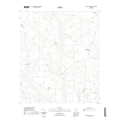
2020 Map of Martins Crossroads
USGS Topo · Published 2020About this map
Pachitla Cr meanders southward through the center of this terrain, serving as the primary drainage for a landscape defined by traditional agricultural settlements and water-powered history. The presence of Goffs Mill and Shivers Mill along their respective namesake creeks, Goffs Mill Cr and Shivers Mill Cr, points to a legacy of local industry tied to the region's waterways. In the northeast, the town of Shellman marks a more concentrated hub, while the rest of the area is interconnected by a network of rural routes such as Fountain Bridge Rd and Martin School Rd. Community life is anchored by longstanding institutions including the Damascus Baptist Church and New Bethel Baptist Church. The southern portion of the map transitions toward the Randolph Co and Calhoun Co line, where the landscape opens into the drainages of Long Br and Menrett Cr.
Find a feature on this map
66 named features on this map. Tap any name to fly to it.
Don’t see what you’re looking for? This feature index may not catch every label — zoom into the map to look around manually.
Map Details
Editions of this 2020 Martins Crossroads Map
This is the sole edition of this map. No revisions or reprints were ever made.
Other maps of this area

1953 · Dothan
USGS Topo · 1:250,000

1954 · Dothan
USGS Topo · 1:250,000

1955 · Dothan
USGS Topo · 1:250,000

1972 · Shellman
USGS Topo · 1:24,000
1972 · Brooksville
USGS Topo · 1:24,000
1972 · Cuthbert
USGS Topo · 1:24,000

1973 · Morgan
USGS Topo · 1:24,000

1973 · Martins Crossroads
USGS Topo · 1:24,000
1973 · Doverel
USGS Topo · 1:24,000

1973 · Edison
USGS Topo · 1:24,000