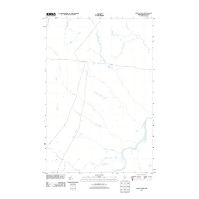
2011 Map of Mary L Pond
USGS Topo · Published 2011About this map
The Saint John River defines the southeastern corner of this Aroostook County landscape, serving as a prominent geographical marker in a region dominated by water and timber transport. This 2011 survey illustrates a sparse infrastructure where Depot Rd and Realty Rd intersect as the primary corridors for forest management and local access. The hydrography of the area is characterized by the central Mary L Pond and a network of drainages including Depot Stream, Ninemile Brook, and Burntland Brook. The map reflects a modern era of land use in northern Maine, where vast tracts are defined by these named water bodies and service roads rather than formal townships or settlements.
Find a feature on this map
7 named features on this map. Tap any name to fly to it.
Don’t see what you’re looking for? This feature index may not catch every label — zoom into the map to look around manually.
Map Details
Editions of this 2011 Mary L Pond Map
This is the sole edition of this map. No revisions or reprints were ever made.
Other maps of this area

1954 · Presque Isle
USGS Topo · 1:250,000

1955 · Depot Lake
USGS Topo · 1:62,500

1955 · Beaver Pond
USGS Topo · 1:62,500

1955 · Clayton Lake
USGS Topo · 1:62,500

1955 · Seven Islands
USGS Topo · 1:62,500

1958 · Presque Isle
USGS Topo · 1:250,000

1960 · Presque Isle
USGS Topo · 1:250,000

1976 · Depot Lake
USGS Topo · 1:24,000
1977 · St. Adalbert
USGS Topo · 1:24,000
1977 · Burntland Pond
USGS Topo · 1:24,000