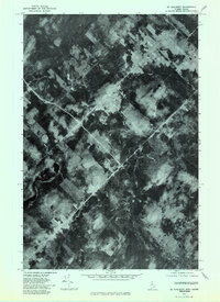
1977 Map of St. Adalbert
USGS Topo · Published 1983About this map
St Adalbert, a community straddling the border of Quebec and Maine, is the focal point of this 1977 orthophotoquad. Unlike a traditional topographic map, this aerial survey provides a direct visual record of the land as it appeared in late November, showing the distinct patchwork of timber harvests and forest regrowth that defines the regional economy. The settlement of St Adalbert itself is visible as a concentration of structures and clearings at the intersection of several logging roads, which cut sharp, geometric lines across the dark evergreen canopy and the frozen wetlands typical of the North Woods. The high-contrast imagery captures the specific state of the logging frontier in the late seventies, revealing exactly which parcels were being actively managed or left to the elements during this era.
Find a feature on this map
1 named feature on this map. Tap any name to fly to it.
Don’t see what you’re looking for? This feature index may not catch every label — zoom into the map to look around manually.
Map Details
Editions of this 1977 St. Adalbert Map
This is the sole edition of this map. No revisions or reprints were ever made.
Other maps of this area

1954 · Presque Isle
USGS Topo · 1:250,000

1955 · Depot Lake
USGS Topo · 1:62,500

1955 · Beaver Pond
USGS Topo · 1:62,500

1958 · Presque Isle
USGS Topo · 1:250,000

1960 · Presque Isle
USGS Topo · 1:250,000

1962 · Quebec
USGS Topo · 1:250,000

1976 · Depot Lake
USGS Topo · 1:24,000
1976 · St. Pamphile
USGS Topo · 1:24,000
1977 · Burntland Pond
USGS Topo · 1:24,000
1986 · St. Pamphile
USGS Topo · 1:24,000