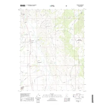
2020 Map of Marysvale
USGS Topo · Published 2020About this map
The Sevier River corridor anchors this portion of Piute County, where the valley floor transitions into the eastern slopes of the Tushar Mountains and the Fishlake National Forest. The settlement of Marysvale serves as the primary hub, situated near the mouth of Marysvale Canyon and the broad expanse of The Bench. A legacy of mining and local ranching is evident in the network of specialized roads, including VCA Mine Rd, Anderson Canyon Mine Rd, and W Deer Trail Mill Rd. Genealogy researchers will find significant value in the distribution of several local burial grounds, such as Mountain View Cem and Murrays Cem near the town center, as well as Thompsonville Cem and Dennis Cem further south near the settlement of Thompsonville. The landscape is further defined by water management features like the Durkee Reservoir and Taylor Ditch.
Find a feature on this map
63 named features on this map. Tap any name to fly to it.
Don’t see what you’re looking for? This feature index may not catch every label — zoom into the map to look around manually.
Map Details
Editions of this 2020 Marysvale Map
This is the sole edition of this map. No revisions or reprints were ever made.
Other maps of this area

1885 · Beaver
USGS Topo · 1:250,000

1932 · Sevier
USGS Topo · 1:62,500

1935 · Sevier
USGS Topo · 1:62,500

1937 · Delano Peak
USGS Topo · 1:48,000

1940 · Monroe
USGS Topo · 1:62,500

1943 · Delano Peak
USGS Topo · 1:62,500

1944 · Monroe
USGS Topo · 1:62,500

1945 · Marysvale
USGS Topo · 1:62,500

1947 · Marysvale
USGS Topo · 1:62,500

1953 · Richfield
USGS Topo · 1:250,000