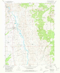
1981 Map of Marysvale
USGS Topo · Published 1981About this map
Marysvale and the surrounding high-desert landscape are defined by the winding course of the Sevier River and the industrial activity of the early 1980s. The town serves as a hub for local life, evidenced by the Rodeo Ground and numerous family and community burial sites like Mountain View Cem and Dennis Cem. The Denver and Rio Grande Western railroad tracks parallel the river, connecting the agricultural valley to the broader region. Mining remains a visible force in the northern hills, with operations at the VCA Mine, Prospector Mine, and Whitehorse Mine appearing near Marysvale Canyon. Further south, the settlement at Alunite and a nearby Landing Strip indicate the specialized industry and transport infrastructure required for this Piute County terrain. The Fishlake National Forest boundary marks the transition to the eastern ridges of the White Hills.
Find a feature on this map
37 named features on this map. Tap any name to fly to it.
Don’t see what you’re looking for? This feature index may not catch every label — zoom into the map to look around manually.
Map Details
Editions of this 1981 Marysvale Map
This is the sole edition of this map. No revisions or reprints were ever made.
Other maps of this area

1885 · Beaver
USGS Topo · 1:250,000

1932 · Sevier
USGS Topo · 1:62,500

1935 · Sevier
USGS Topo · 1:62,500

1937 · Delano Peak
USGS Topo · 1:48,000

1940 · Monroe
USGS Topo · 1:62,500

1943 · Delano Peak
USGS Topo · 1:62,500

1944 · Monroe
USGS Topo · 1:62,500

1945 · Marysvale
USGS Topo · 1:62,500

1947 · Marysvale
USGS Topo · 1:62,500

1953 · Richfield
USGS Topo · 1:250,000