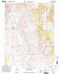
2001 Map of Marysvale
USGS Topo · Published 2003About this map
Marysvale serves as the central hub of this Marysvale Valley landscape, positioned where Beaver Creek and Pine Creek emerge from the west to join the Sevier River. The town’s layout reflects its dual identity as an agricultural center and a gateway to the surrounding mining districts, evidenced by the Rodeo Ground and nearby Landing Strip. To the south, the settlement of Alunite and a nearby Substa point to the area’s industrial heritage, while numerous extraction sites like the Prospector Mine and Freedom Mine pepper the slopes of the White Hills.
Find a feature on this map
41 named features on this map. Tap any name to fly to it.
Don’t see what you’re looking for? This feature index may not catch every label — zoom into the map to look around manually.
Map Details
Editions of this 2001 Marysvale Map
This is the sole edition of this map. No revisions or reprints were ever made.
Other maps of this area

1885 · Beaver
USGS Topo · 1:250,000

1932 · Sevier
USGS Topo · 1:62,500

1935 · Sevier
USGS Topo · 1:62,500

1937 · Delano Peak
USGS Topo · 1:48,000

1940 · Monroe
USGS Topo · 1:62,500

1943 · Delano Peak
USGS Topo · 1:62,500

1944 · Monroe
USGS Topo · 1:62,500

1945 · Marysvale
USGS Topo · 1:62,500

1947 · Marysvale
USGS Topo · 1:62,500

1953 · Richfield
USGS Topo · 1:250,000