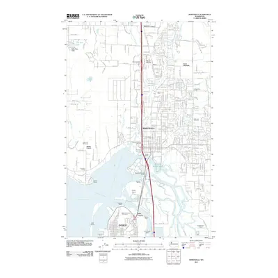
2011 Map of Marysville
USGS Topo · Published 2011About this map
Quilceda Creek and its various forks define the hydrological landscape north of the Snohomish River delta, where the city of Marysville meets the northern edge of Everett. This early 21st-century survey documents the dense suburban development patterns and transportation nodes such as Kruse Junction and Delta Junction, alongside legacy landmarks like the Shaker Church and Kellogg Marsh School. The map highlights the complex estuarine environment south of the city, characterized by a network of waterways including Ebey Slough, Steamboat Slough, and Union Slough which wrap around Smith Island. These tidewaters are home to maritime infrastructure like Dagmars Marina and the Steamboat Slough Bridge. To the west, the Western Washington Indian Agency and Priest Point mark the transition toward Possession Sound, while the interior is dotted with community hubs like the Priest Point Grange and Stimson Crossing.
Find a feature on this map
133 named features on this map. Tap any name to fly to it.
Don’t see what you’re looking for? This feature index may not catch every label — zoom into the map to look around manually.
Map Details
Editions of this 2011 Marysville Map
This is the sole edition of this map. No revisions or reprints were ever made.
Other maps of this area

1895 · Snohomish
USGS Topo · 1:125,000

1897 · Seattle
USGS Topo · 1:125,000

1911 · Mount Vernon
USGS Topo · 1:125,000

1941 · Marysville
USGS Topo · 1:62,500

1942 · Edmonds
USGS Topo · 1:62,500

1943 · Marysville
USGS Topo · 1:62,500

1943 · Stanwood
USGS Topo · 1:62,500

1944 · Everett
USGS Topo · 1:62,500
1953 · Snohomish
USGS Topo · 1:24,000
1953 · Mukilteo
USGS Topo · 1:24,000