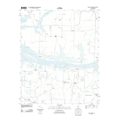
2011 Map of Mason Ridge
USGS Topo · Published 2011About this map
Wheeler Lake and the Tennessee River dominate this 2011 survey, illustrating the significant hydrological engineering of northern Alabama. The landscape is marked by numerous family-named burial grounds, such as Peebles Cemetery, the Blackwell-Collier Cemetery, and Hunley Cemetery, which serve as vital markers for local genealogical research. Small settlements and rural intersections like Swancott, New Hope, and Echols Crossroads are connected by a network of roads including Wall Triana Hwy and Boeing Blvd SW. Significant terrain features such as Turkey Mountain, Thompson Hollow, and the Sand Mountain High Ridge define the elevation changes south of the river. The presence of Rockhouse Landing and Cain Landing along the northern banks of the waterway indicates the historical and modern importance of river access in Madison County.
Find a feature on this map
100 named features on this map. Tap any name to fly to it.
Don’t see what you’re looking for? This feature index may not catch every label — zoom into the map to look around manually.
Map Details
Editions of this 2011 Mason Ridge Map
This is the sole edition of this map. No revisions or reprints were ever made.
Other maps of this area

1888 · Cullman
USGS Topo · 1:125,000

1888 · Huntsville
USGS Topo · 1:125,000

1892 · Cullman
USGS Topo · 1:125,000

1892 · Huntsville
USGS Topo · 1:125,000

1936 · Triana
USGS Topo · 1:24,000

1936 · Madison
USGS Topo · 1:24,000

1936 · Hartselle
USGS Topo · 1:24,000

1936 · Decatur
USGS Topo · 1:24,000

1936 · Somerville
USGS Topo · 1:24,000

1936 · Center Grove
USGS Topo · 1:24,000