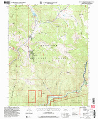
2001 Map of Matchless Mountain
USGS Topo · Published 2004About this map
Gunnison National Forest land defines this corner of the Colorado high country at the turn of the 21st century, where the mining legacy of the Elk Mountains meets modern recreation. The topography is dominated by the massive ridge line of Matchless Mountain and South Matchless Mountain, descending into the deep drainage of Taylor Canyon. Resource extraction is evident at the Doctor Mine and multiple mines and prospects near Manganese Peak, while the Colorado Trail and Gunnison Spur reflect the area's transition toward wilderness management. Notable water features include the Spring Creek Reservoir with its boat ramp at the northern edge, and the Taylor River flowing through the southern canyons near Lodgepole. The presence of the Fossil Ridge Wilderness in the southeast indicates the high degree of conservation within this high-altitude landscape.
Find a feature on this map
77 named features on this map. Tap any name to fly to it.
Don’t see what you’re looking for? This feature index may not catch every label — zoom into the map to look around manually.
Map Details
Editions of this 2001 Matchless Mountain Map
This is the sole edition of this map. No revisions or reprints were ever made.
Other maps of this area

1888 · Crested Butte
USGS Topo · 1:62,500

1889 · Crested Butte
USGS Topo · 1:62,500

1893 · Crested Butte
USGS Topo · 1:62,500

1934 · Taylor Park
USGS Topo · 1:62,500

1937 · Taylor Park
USGS Topo · 1:62,500

1941 · Pitkin
USGS Topo · 1:62,500

1945 · Pitkin
USGS Topo · 1:62,500

1956 · Montrose
USGS Topo · 1:250,000

1959 · Montrose
USGS Topo · 1:250,000

1960 · Montrose
USGS Topo · 1:250,000