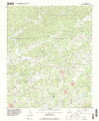
1993 Map of Matt
USGS Topo · Published 1999About this map
The Etowah River carves through this North Georgia landscape, defining the northern reaches near the Dawson Forest State Wildlife Management Area. The terrain is marked by a network of winding roads and rural communities like Matt, Heardville, and Barrettsville that reflect the agricultural and early developmental patterns of Forsyth and Dawson Counties. A standout local landmark is the Covered Bridge located along the river southwest of Hightower, illustrating the historical engineering and transport routes once vital to the area.
Find a feature on this map
52 named features on this map. Tap any name to fly to it.
Don’t see what you’re looking for? This feature index may not catch every label — zoom into the map to look around manually.
Map Details
Editions of this 1993 Matt Map
This is the sole edition of this map. No revisions or reprints were ever made.
Other maps of this area

1890 · Suwanee
USGS Topo · 1:125,000

1894 · Suwanee
USGS Topo · 1:125,000

1926 · Tate
USGS Topo · 1:62,500

1928 · Tate
USGS Topo · 1:62,500

1955 · Rome
USGS Topo · 1:250,000

1956 · Birmingham
USGS Topo · 1:24,000

1958 · Rome
USGS Topo · 1:250,000

1961 · Rome
USGS Topo · 1:250,000

1963 · Rome
USGS Topo · 1:250,000
1964 · Juno
USGS Topo · 1:24,000