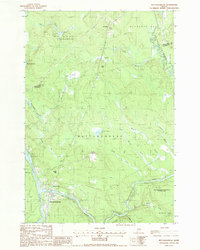
1988 Map of Mattawamkeag
USGS Topo · Published 1988About this map
Mattawamkeag sits at the confluence of the Penobscot River and the Mattawamkeag River in this late-1980s landscape of wetlands and woods. The settlement patterns reflect the area's transition from river-dependent industry to modern recreation, highlighted by the Mattawamkeag Wilderness County Park and the nearby Campground. Pockets of local history appear at Meadowville and the Back Settlement, which is located near Back Settlement Pond. The terrain is defined by low-lying bogs and streams, such as Sunken Bog and Fog Brook, which separate distinct ridges like Webb Hill and Beech Hill. Industrial traces remain visible through the Gravel Pit near the Molunkus Stream and the Boom Islands in the Penobscot, indicating the river's historical role in timber management. To the north, the township of Molunkus serves as a remote anchor in this heavily forested portion of Penobscot and Aroostook counties.
Find a feature on this map
40 named features on this map. Tap any name to fly to it.
Don’t see what you’re looking for? This feature index may not catch every label — zoom into the map to look around manually.
Map Details
Editions of this 1988 Mattawamkeag Map
This is the sole edition of this map. No revisions or reprints were ever made.
Other maps of this area

1920 · Winn
USGS Topo · 1:62,500

1931 · Springfield
USGS Topo · 1:48,000

1934 · Springfield
USGS Topo · 1:62,500

1940 · Mattawamkeag
USGS Topo · 1:62,500

1941 · Wytopitlock
USGS Topo · 1:62,500

1942 · Mattawamkeag
USGS Topo · 1:62,500

1943 · Wytopitlock
USGS Topo · 1:62,500

1954 · Millinocket
USGS Topo · 1:250,000

1958 · Millinocket
USGS Topo · 1:250,000

1960 · Millinocket
USGS Topo · 1:250,000