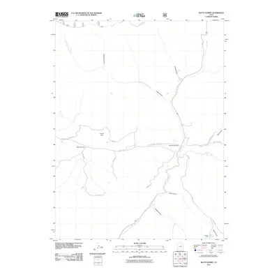
2011 Map of Matts Summit
USGS Topo · Published 2011About this map
Matts Summit and the high country of Utah County are defined by a complex network of canyons and seasonal water sources in this 2011 survey. The landscape is marked by a transition from the lower reaches of Willow Creek to the elevated ranching and grazing grounds of Emma Park. Human impact is visible through small-scale water management like Little Boulder Dam and the network of backroads including Emma Park Rd and Sulpher Rd that navigate the varied terrain.
Find a feature on this map
27 named features on this map. Tap any name to fly to it.
Don’t see what you’re looking for? This feature index may not catch every label — zoom into the map to look around manually.
Map Details
Editions of this 2011 Matts Summit Map
This is the sole edition of this map. No revisions or reprints were ever made.
Other maps of this area

1886 · Price River
USGS Topo · 1:250,000

1896 · Price River
USGS Topo · 1:250,000

1914 · Castle Gate
USGS Topo · 1:62,500

1915 · Wellington
USGS Topo · 1:62,500

1916 · Castle Gate
USGS Topo · 1:62,500

1956 · Price
USGS Topo · 1:250,000

1960 · Price
USGS Topo · 1:250,000

1962 · Price
USGS Topo · 1:250,000
1968 · Jones Hollow
USGS Topo · 1:24,000
1969 · Flat Ridge
USGS Topo · 1:24,000