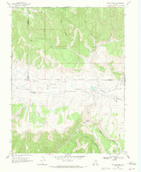
1969 Map of Matts Summit
USGS Topo · Published 1971About this map
Ashley National Forest and the high plateaus of the Roan Cliffs dominate this topographic study of the Utah backcountry. The landscape is defined by the sharp transition from the forested heights of Indian Treaty Ridge down to the open expanse of Emma Park. This high-altitude basin serves as a natural corridor between the mountain ranges, where early water management is evident at Little Boulder Dam and Pace Pond. Settlement is sparse, represented only by isolated landmarks like the Downard Cabin and the namesake Matts Summit. The network of Jeep Trails and drainage features such as Willow Creek and Deep Canyon trace a remote territory focused on livestock grazing and resource extraction, including a Gravel Pit located near the Duchesne and Carbon county line.
Find a feature on this map
26 named features on this map. Tap any name to fly to it.
Don’t see what you’re looking for? This feature index may not catch every label — zoom into the map to look around manually.
Map Details
Editions of this 1969 Matts Summit Map
This is the sole edition of this map. No revisions or reprints were ever made.
Other maps of this area

1886 · Price River
USGS Topo · 1:250,000

1896 · Price River
USGS Topo · 1:250,000

1914 · Castle Gate
USGS Topo · 1:62,500

1915 · Wellington
USGS Topo · 1:62,500

1916 · Castle Gate
USGS Topo · 1:62,500

1956 · Price
USGS Topo · 1:250,000

1960 · Price
USGS Topo · 1:250,000

1962 · Price
USGS Topo · 1:250,000
1968 · Jones Hollow
USGS Topo · 1:24,000
1969 · Flat Ridge
USGS Topo · 1:24,000