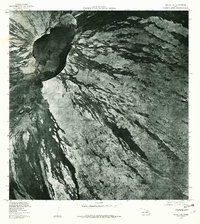
1978 Map of Mauna Loa
USGS Topo · Published 1981About this map
Mauna Loa dominates this orthophotoquad, which uses aerial photography from the late 1970s to provide a detailed view of the volcanic summit. The distinct, dark boundary of the Mokuaweoweo caldera is the primary focal point, showing the stark contrast between various lava flow ages and compositions. Surrounding the main caldera, several pit craters are clearly visible, including Lua Poholo to the north and Lua Hohonu and Lua Hou to the south. Produced by the Geological Survey in cooperation with the State of Hawaii, this document serves as a specific visual record of the mountain's morphology following decades of volcanic activity. The imagery reveals the complex patterns of drainage and flow that define the shield volcano's upper slopes before later eruptions further altered the surface.
Find a feature on this map
5 named features on this map. Tap any name to fly to it.
Don’t see what you’re looking for? This feature index may not catch every label — zoom into the map to look around manually.
Map Details
Editions of this 1978 Mauna Loa Map
This is the sole edition of this map. No revisions or reprints were ever made.
Other maps of this area

1921 · Kilauea
USGS Topo · 1:62,500

1924 · Kilauea
USGS Topo · 1:62,500

1927 · Kaohe
USGS Topo · 1:62,500

1928 · Mauna Loa
USGS Topo · 1:62,500

1930 · Humuula
USGS Topo · 1:62,500

1930 · Kaohe
USGS Topo · 1:62,500

1954 · Hawaii South
USGS Topo · 1:250,000

1954 · Hawaii North
USGS Topo · 1:250,000
1956 · Puu Ulaula
USGS Topo · 1:24,000

1956 · Puu O Uo
USGS Topo · 1:24,000