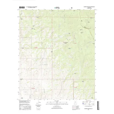
2017 Map of Maverick Mountain
USGS Topo · Published 2017About this map
Gila National Forest encompasses the center of this terrain, dominated by the peaks of the Black Range and the distinctive profile of Maverick Mountain. The map reveals a high-altitude landscape where water management is critical for survival and land use, evidenced by a network of isolated water sources such as Upton Cabin Well, Hot Springs Well, and Twin Calf Tank. These features, along with the numerous named canyons like Silver Creek Canyon and Gold Pan Canyon, suggest a history of prospecting and ranching that shaped the region’s development. The presence of Royal John Mine Rd and Silver Creek Rd provides a look at the remote access routes into these rugged reaches of Grant Co, while landmarks like Sawyers Peak and Noonday Peak serve as prominent navigational anchors for those traversing the mountain passes.
Find a feature on this map
47 named features on this map. Tap any name to fly to it.
Don’t see what you’re looking for? This feature index may not catch every label — zoom into the map to look around manually.
Map Details
Editions of this 2017 Maverick Mountain Map
This is the sole edition of this map. No revisions or reprints were ever made.
Other maps of this area

1935 · Hillsboro
USGS Topo · 1:48,000

1940 · Hillsboro
USGS Topo · 1:62,500

1955 · Las Cruces
USGS Topo · 1:250,000

1956 · Dwyer
USGS Topo · 1:62,500

1956 · San Lorenzo
USGS Topo · 1:62,500

1958 · Las Cruces
USGS Topo · 1:250,000

1962 · Lake Valley
USGS Topo · 1:62,500

1982 · Hatch
USGS Topo · 1:100,000
1985 · Dwyer
USGS Topo · 1:24,000
1985 · P A Mountain
USGS Topo · 1:24,000