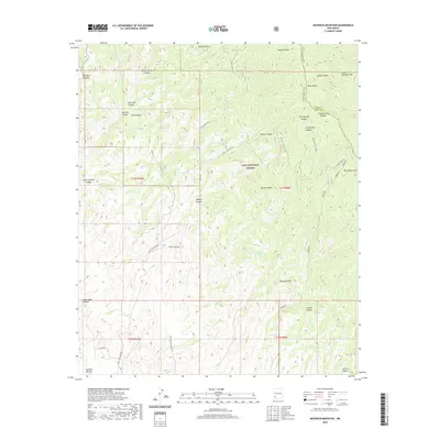
2020 Map of Maverick Mountain
USGS Topo · Published 2020About this map
The Gila National Forest dominates this section of the Black Range, where the crest of the mountains serves as the dividing line between Grant and Sierra counties. This high-altitude landscape is defined by its network of canyons and peaks, including Maverick Mtn and the prominent Sawyers Peak to the north. Resource extraction and cattle ranching have left their mark on the terrain via the Royal John Mine Rd and a system of upland water catchments like Twin Calf Tank and Upton Tank. Evidence of prospectors and early settlers appears in labels such as Gold Pan Canyon and Quien Sabe Canyon. The map reveals the logistical challenges of the area, with routes like Silver Creek Rd following the natural contours of the steep drainages.
Find a feature on this map
41 named features on this map. Tap any name to fly to it.
Don’t see what you’re looking for? This feature index may not catch every label — zoom into the map to look around manually.
Map Details
Editions of this 2020 Maverick Mountain Map
This is the sole edition of this map. No revisions or reprints were ever made.
Other maps of this area

1935 · Hillsboro
USGS Topo · 1:48,000

1940 · Hillsboro
USGS Topo · 1:62,500

1955 · Las Cruces
USGS Topo · 1:250,000

1956 · Dwyer
USGS Topo · 1:62,500

1956 · San Lorenzo
USGS Topo · 1:62,500

1958 · Las Cruces
USGS Topo · 1:250,000

1962 · Lake Valley
USGS Topo · 1:62,500

1982 · Hatch
USGS Topo · 1:100,000
1985 · Dwyer
USGS Topo · 1:24,000
1985 · P A Mountain
USGS Topo · 1:24,000