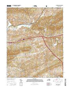
2016 Map of Max Meadows
USGS Topo · Published 2016About this map
The iron and furnace history of Wythe County is etched across this landscape, centered on the community of Walton Furnace and the surrounding mineral-rich slopes. Industrial heritage is preserved through features like Sanders Mines Rd and the Walton Furnace Rd, which trace the legacy of resource extraction near Raper Ridge. In the northern reach, the Jefferson National Forest covers the high ground of Little Brush Mtn, while the fertile corridor along Reed Creek supports established settlements such as Max Meadows and Fort Chiswell. Local genealogy is anchored by the Jacob McGavock Cem and James McGavock Cem, resting near the Keesline Bridge. The terrain shifts from the agricultural flats of Red Hollow to the prominent heights of Lick Mtn, illustrating the varied geography of this Appalachian valley.
Find a feature on this map
114 named features on this map. Tap any name to fly to it.
Don’t see what you’re looking for? This feature index may not catch every label — zoom into the map to look around manually.
Map Details
Editions of this 2016 Max Meadows Map
This is the sole edition of this map. No revisions or reprints were ever made.
Other maps of this area

1887 · Pocahontas
USGS Topo · 1:125,000

1889 · Hillsville
USGS Topo · 1:125,000

1889 · Wytheville
USGS Topo · 1:125,000

1890 · Dublin
USGS Topo · 1:125,000

1891 · Pocahontas
USGS Topo · 1:125,000

1891 · Dublin
USGS Topo · 1:125,000

1892 · Hillsville
USGS Topo · 1:125,000

1892 · Wytheville
USGS Topo · 1:125,000

1894 · Pocahontas
USGS Topo · 1:125,000

1895 · Pocahontas
USGS Topo · 1:125,000