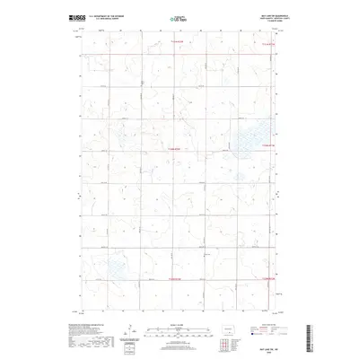
2020 Map of May Lake SW
USGS Topo · Published 2020About this map
New Kassel Cem and Kassel Cem serve as the primary historic landmarks in this quiet section of rural North Dakota. The landscape is defined by the rigid grid of section-line roads, including 91st St SE and 32nd Ave SE, which partition the undulating terrain into standardized agricultural blocks. A series of unnamed small lakes and wetlands dot the central and eastern portions of the quadrangle, particularly along 93rd St SE, suggesting a drainage pattern common to the glaciated plains. The preservation of these two cemeteries amidst the sprawling farmland provides a specific point of reference for genealogists tracing early settlement patterns in this part of McIntosh County.
Find a feature on this map
21 named features on this map. Tap any name to fly to it.
Don’t see what you’re looking for? This feature index may not catch every label — zoom into the map to look around manually.
Map Details
Editions of this 2020 May Lake SW Map
This is the sole edition of this map. No revisions or reprints were ever made.
Other maps of this area

1953 · Jamestown
USGS Topo · 1:250,000

1954 · Aberdeen
USGS Topo · 1:250,000

1956 · Aberdeen
USGS Topo · 1:250,000

1956 · Jamestown
USGS Topo · 1:250,000

1978 · Greenway
USGS Topo · 1:24,000

1978 · Zeeland
USGS Topo · 1:24,000

1978 · Venturia
USGS Topo · 1:24,000
1980 · Hague SE
USGS Topo · 1:24,000

1982 · May Lake NW
USGS Topo · 1:24,000

1982 · May Lake SW
USGS Topo · 1:24,000