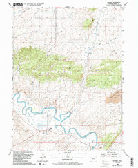
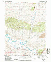
1986 Map of Maybell
USGS Topo · Published 1986About this map
The Yampa River winds through this 1986 survey, defining the valley's character and the small settlement of Maybell in Moffat County. The landscape here is one of high-desert transitions, where water sources like Omsted Spring and Barber Spring provided critical points of interest in an arid terrain marked by Hat Hill and Eagle Rock. Local infrastructure is well-documented, showing the town's Rodeo Ground, a Landing Strip, and a small Cem on the bench overlooking the river. Evidence of the region's extractive economy appears on the eastern edge of the sheet with a significant Strip Mine, while numerous smaller features like Prospect excavations and a Gravel Pit dot the surroundings. The map captures the complex water management system of the era, including a Pumping Sta, a Ditch, and even an Aqueduct near the river's bend.
Find a feature on this map
30 named features on this map. Tap any name to fly to it.
Don’t see what you’re looking for? This feature index may not catch every label — zoom into the map to look around manually.
Map Details
Editions of this 1986 Maybell Map
2 editions found
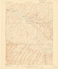
Other maps of this area

1907 · White River
USGS Topo · 1:125,000

1910 · Danforth Hills
USGS Topo · 1:125,000

1910 · White River
USGS Topo · 1:125,000

1912 · Axial
USGS Topo · 1:62,500
1914 · Axial
USGS Topo · 1:62,500

1916 · Craig
USGS Topo · 1:125,000

1954 · Vernal
USGS Topo · 1:250,000

1954 · Craig
USGS Topo · 1:250,000

1957 · Craig
USGS Topo · 1:250,000

1958 · Vernal
USGS Topo · 1:250,000