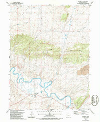
1986 Map of Maybell
USGS Topo · Published 1986About this map
The small community of Maybell serves as the focal point of this Moffat County survey, situated just north of a prominent bend in the Yampa River. The landscape here is defined by the intersection of high desert ranching and industrial extraction, evidenced by the Strip Mine to the east and various Gravel Pit sites along the riverbanks. Local infrastructure supports the rural population through a Rodeo Ground, a Cem (cemetery), and a Landing Strip, while water management is highlighted by a complex system including a Pumping Sta, Gaging Sta, and a long-distance Aqueduct. Topographic landmarks like Eagle Rock and Hat Hill break the plateau, which is otherwise marked by several natural springs such as Olmsted Spring and Barber Spring. This 1980s data provides a record of the region's land use before later shifts in mining and conservation changed the Yampa Valley's economic footprint.
Find a feature on this map
31 named features on this map. Tap any name to fly to it.
Don’t see what you’re looking for? This feature index may not catch every label — zoom into the map to look around manually.
Map Details
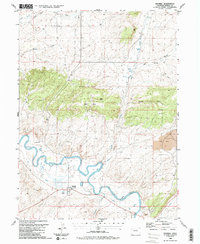
Editions of this 1986 Maybell Map
2 editions found
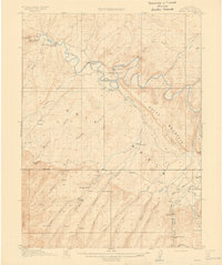
Other maps of this area

1907 · White River
USGS Topo · 1:125,000

1910 · Danforth Hills
USGS Topo · 1:125,000

1910 · White River
USGS Topo · 1:125,000

1912 · Axial
USGS Topo · 1:62,500
1914 · Axial
USGS Topo · 1:62,500

1916 · Craig
USGS Topo · 1:125,000

1954 · Vernal
USGS Topo · 1:250,000

1954 · Craig
USGS Topo · 1:250,000

1957 · Craig
USGS Topo · 1:250,000

1958 · Vernal
USGS Topo · 1:250,000