1907 Map of White River
USGS Topo · Published 1957About this map
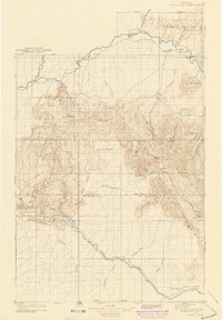
The Yampa River and White River systems dominate this early 20th-century landscape, providing the lifeblood for isolated ranching outposts and pioneer settlements. At the northern edge, the community of Maybell P O serves as a vital hub near the Fraker Ford Bridge, while the settlement of Lily sits further west where the Little Snake River meets the Yampa. The map reveals a land defined by its water sources, from Twelvemile Springs to the irrigation potential of Powell Park in the south.
Find a feature on this map
51 named features on this map. Tap any name to fly to it.
Don’t see what you’re looking for? This feature index may not catch every label — zoom into the map to look around manually.
Map Details
Editions of this 1907 White River Map
This is the sole edition of this map. No revisions or reprints were ever made.