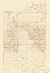
1910 Map of White River
USGS Topo · Published 1942About this map
The Yampa River and the White River anchor this northwestern Colorado landscape, recorded during a 1907 survey and updated into the early 1940s. The terrain is defined by dramatic elevation changes, from the heights of Wapiti Peak and Juniper Mtn to the expansive Coyote Basin and Citadel Plateau. Human presence is sparse, centered on small outposts like Maybell P O and Lily. Early infrastructure is visible through crossings such as the Thornburgh Bridge and the Fraker Ford Bridge, which facilitated movement across the high desert and river valleys. The boundary between Routt and Rio Blanco Counties bisects the sheet, cutting through the Deep Channel. In the southeast, Powell Park borders the winding course of the White River, while smaller family and geological landmarks like Keystone Ranch and Clinker Knobs suggest the local ranching and mining history of the era.
Find a feature on this map
47 named features on this map. Tap any name to fly to it.
Don’t see what you’re looking for? This feature index may not catch every label — zoom into the map to look around manually.
Map Details
Editions of this 1910 White River Map
2 editions found
Other maps of this area

1906 · Grand Hogback
USGS Topo · 1:125,000

1907 · Rangely
USGS Topo · 1:125,000

1907 · White River
USGS Topo · 1:125,000

1910 · Danforth Hills
USGS Topo · 1:125,000

1910 · Grand Hogback
USGS Topo · 1:125,000

1910 · White River
USGS Topo · 1:125,000

1910 · Rangely
USGS Topo · 1:125,000

1912 · Meeker
USGS Topo · 1:62,500

1912 · Axial
USGS Topo · 1:62,500

1914 · Meeker
USGS Topo · 1:62,500