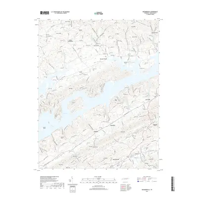
2019 Map of Maynardville
USGS Topo · Published 2019About this map
Maynardville sits at the southern base of Hinds Ridge, anchoring a landscape defined by the long, parallel limestone valleys and ridges of East Tennessee. The intricate shoreline of Norris Lake dominates the central portion of the map, surrounding features like Island F and Rabbit Island where the Clinch River once flowed freely through Big Valley. This modern survey illustrates how historical settlements like Sharps Chapel and Rose Hill have transitioned into lakeside communities, while smaller locales like Lickskillet and Pinhook remain tucked within the folds of the terrain. Genealogists will find a dense distribution of family burial grounds, including the Skaggs Cem in the county seat and the Big Barren Cem near Little Valley. The map also captures the local transportation network, from the Lake View Airport to the winding paths of Hickory Valley Rd.
Find a feature on this map
198 named features on this map. Tap any name to fly to it.
Don’t see what you’re looking for? This feature index may not catch every label — zoom into the map to look around manually.
Map Details
Editions of this 2019 Maynardville Map
This is the sole edition of this map. No revisions or reprints were ever made.
Other maps of this area

1897 · Maynardville
USGS Topo · 1:125,000

1900 · Maynardville
USGS Topo · 1:125,000

1935 · Luttrell
USGS Topo · 1:24,000

1935 · Straw Plains
USGS Topo · 1:48,000

1935 · Graveston
USGS Topo · 1:24,000

1935 · Well Spring
USGS Topo · 1:24,000

1936 · Gorryton
USGS Topo · 1:48,000

1936 · Powder Springs
USGS Topo · 1:24,000

1936 · Ausmus
USGS Topo · 1:24,000
1936 · Clouds
USGS Topo · 1:24,000