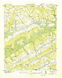
1936 Map of Maynardville
USGS Topo · Published 1936About this map
Norris Reservoir dominates this landscape, its newly formed waters reaching into the valleys of Big Ridge and Clinch Mountain. This 1936 survey documents the Tennessee Valley Authority's transformative impact on Union County, showing the Norris Reservoir Boundary as it encroached upon established farming communities. Local industry and commerce are marked by the Berry Peter Mill and crossroads locations like Ellisons Store and Weichs Store.
Find a feature on this map
82 named features on this map. Tap any name to fly to it.
Don’t see what you’re looking for? This feature index may not catch every label — zoom into the map to look around manually.
Map Details
Editions of this 1936 Maynardville Map
This is the sole edition of this map. No revisions or reprints were ever made.
Other maps of this area

1897 · Maynardville
USGS Topo · 1:125,000

1900 · Maynardville
USGS Topo · 1:125,000

1935 · Luttrell
USGS Topo · 1:24,000

1935 · Straw Plains
USGS Topo · 1:48,000

1935 · Graveston
USGS Topo · 1:24,000

1935 · Well Spring
USGS Topo · 1:24,000

1936 · Gorryton
USGS Topo · 1:48,000

1936 · Powder Springs
USGS Topo · 1:24,000

1936 · Ausmus
USGS Topo · 1:24,000
1936 · Clouds
USGS Topo · 1:24,000