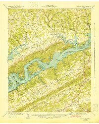
1941 Map of Maynardville
USGS Topo · Published 1941About this map
Norris Reservoir dominates the central landscape of this 1941 Tennessee Valley Authority survey, as the waters of the Clinch River back into the hollows and ridges of Union County. The era's massive hydroelectric and flood control efforts are visible through the expansive Norris Reservation boundaries, which encompass numerous family-named landmarks and former agricultural sites. Local commerce and communal life are anchored at Sharps Chapel, Ellisons Store, and Welch Crossroad, while industry is represented by the Berry Peters Mill near Lost Creek Spring. The terrain is characterized by complex limestone formations, including the Big Sinks and numerous named gaps like Malone Gap and Butcher Gap that provided passage through Pine Ridge and Hickory Valley. Genealogists will find a wealth of specific data points, including the Stiner Cem, Buckner Cem, and Beeler Cem, alongside local schools such as Oakland Sch and Buckner Sch.
Find a feature on this map
81 named features on this map. Tap any name to fly to it.
Don’t see what you’re looking for? This feature index may not catch every label — zoom into the map to look around manually.
Map Details
Editions of this 1941 Maynardville Map
This is the sole edition of this map. No revisions or reprints were ever made.
Other maps of this area

1897 · Maynardville
USGS Topo · 1:125,000

1900 · Maynardville
USGS Topo · 1:125,000

1935 · Luttrell
USGS Topo · 1:24,000

1935 · Straw Plains
USGS Topo · 1:48,000

1935 · Graveston
USGS Topo · 1:24,000

1935 · Well Spring
USGS Topo · 1:24,000

1936 · Gorryton
USGS Topo · 1:48,000

1936 · Powder Springs
USGS Topo · 1:24,000

1936 · Ausmus
USGS Topo · 1:24,000
1936 · Clouds
USGS Topo · 1:24,000