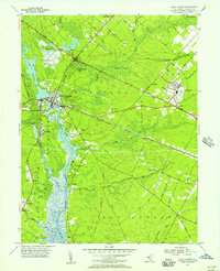
1955 Map of Mays Landing
USGS Topo · Published 1956About this map
The Great Egg Harbor River carves a central path through this mid-century landscape, acting as a primary artery for small riverfront settlements like Catawba and Thompsontown. In the northwest, Lake Lenape and its Lookout Tower anchor the prominent county seat at Mays Landing, where the local economy transitions from the water's edge to the inland pine barrens. The presence of the Atlantic City Racetrack near McKee City highlights the post-war recreational development of Atlantic County, contrasted by the quiet persistence of agricultural and religious hubs like the German Ch and Union Cem.
Find a feature on this map
67 named features on this map. Tap any name to fly to it.
Don’t see what you’re looking for? This feature index may not catch every label — zoom into the map to look around manually.
Map Details
Editions of this 1955 Mays Landing Map
3 editions found
Other maps of this area

1890 · Great Egg Harbor
USGS Topo · 1:62,500

1890 · Hammonton
USGS Topo · 1:62,500

1890 · Tuckahoe
USGS Topo · 1:62,500

1890 · Mullica
USGS Topo · 1:62,500

1893 · Great Egg Harbor
USGS Topo · 1:62,500

1893 · Tuckahoe
USGS Topo · 1:62,500

1894 · Hammonton
USGS Topo · 1:62,500

1894 · Mullica
USGS Topo · 1:62,500

1898 · Mullica
USGS Topo · 1:62,500

1898 · Hammonton
USGS Topo · 1:62,500
Featured Places
- Egg Harbor Township, NJ
- Galloway Township, NJ
- Hamilton Township, NJ
- Weymouth Township, NJ
- Estell Manor, NJ