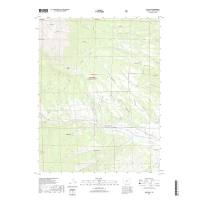
2019 Map of Maysville
USGS Topo · Published 2019About this map
Mt Shavano dominates the northern reaches of this Colorado landscape, part of a high-altitude terrain where the San Isabel National Forest meets the valley floor. The settlement of Maysville sits as a primary point of reference along the southern edge of the peak's shadow, near the convergence of numerous drainage gulches and creek beds. The map illustrates an intricate system of water management essential to the region, including the Cameron Ditch, Missouri Park Ditch, and N Fork Ditch, which redirect flow from the S Arkansas River and its tributaries. This network of irrigation channels underscores the transition from the steep alpine slopes of Mt. Shavano to the managed agricultural and residential lands below. High-country landmarks such as Shavano Lake and Pooses Lake are also documented, alongside contemporary trails like the Tabeguache Th.
Find a feature on this map
55 named features on this map. Tap any name to fly to it.
Don’t see what you’re looking for? This feature index may not catch every label — zoom into the map to look around manually.
Map Details
Editions of this 2019 Maysville Map
This is the sole edition of this map. No revisions or reprints were ever made.
Other maps of this area

1940 · Garfield
USGS Topo · 1:62,500

1945 · Garfield
USGS Topo · 1:62,500

1956 · Poncha Springs
USGS Topo · 1:62,500

1956 · Montrose
USGS Topo · 1:250,000

1959 · Montrose
USGS Topo · 1:250,000

1959 · Bonanza
USGS Topo · 1:62,500

1960 · Montrose
USGS Topo · 1:250,000

1967 · Pahlone Peak
USGS Topo · 1:24,000

1968 · Montrose
USGS Topo · 1:250,000
1980 · Poncha Pass
USGS Topo · 1:24,000