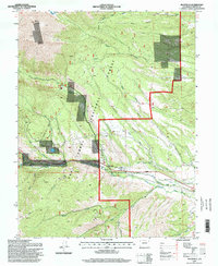
1994 Map of Maysville
USGS Topo · Published 1998About this map
San Isabel National Forest dominates this high-altitude landscape in Chaffee Co, where the dramatic slopes of Mount Shavano rise above the South Arkansas River valley. The small settlement of Maysville sits along the river corridor, supported by water management infrastructure including the Aqueduct and Hoosier Ditch. This 1994 survey reflects a late 20th-century mix of recreation and resource management, with the Colorado Trail winding through the timber and numerous prospects and mines scattered across the mountain flanks. Notable features like the Angel of Shavano and Shavano Lake sit at the higher elevations, while lower areas like Missouri Park show the irrigation networks essential to the region's geography. A local Cem and a Mobile Home Park provide points of interest for genealogists and local historians tracing the development of this mountain community.
Find a feature on this map
37 named features on this map. Tap any name to fly to it.
Don’t see what you’re looking for? This feature index may not catch every label — zoom into the map to look around manually.
Map Details
Editions of this 1994 Maysville Map
This is the sole edition of this map. No revisions or reprints were ever made.
Other maps of this area

1940 · Garfield
USGS Topo · 1:62,500

1945 · Garfield
USGS Topo · 1:62,500

1956 · Poncha Springs
USGS Topo · 1:62,500

1956 · Montrose
USGS Topo · 1:250,000

1959 · Montrose
USGS Topo · 1:250,000

1959 · Bonanza
USGS Topo · 1:62,500

1960 · Montrose
USGS Topo · 1:250,000

1967 · Pahlone Peak
USGS Topo · 1:24,000

1968 · Montrose
USGS Topo · 1:250,000
1980 · Poncha Pass
USGS Topo · 1:24,000