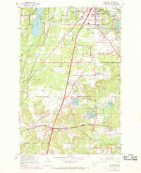
1959 Map of Maytown
USGS Topo · Published 1969About this map
The Deschutes River and several major railroads anchor this survey of the southern Puget Sound region during a period of mid-century infrastructure growth. The landscape is a mix of agricultural flats and lowland prairies, including Bush Prairie and Rocky Prairie, punctuated by a series of small lakes like Scott Lake and Deep Lake. The industrial and transportation corridor is particularly active, evidenced by the convergence of the Northern Pacific, Union Pacific, and the Chicago Milwaukee St Paul and Pacific railroads near Tumwater.
Find a feature on this map
57 named features on this map. Tap any name to fly to it.
Don’t see what you’re looking for? This feature index may not catch every label — zoom into the map to look around manually.
Map Details
Editions of this 1959 Maytown Map
3 editions found
Other maps of this area

1916 · Chehalis
USGS Topo · 1:125,000

1937 · Olympia
USGS Topo · 1:62,500

1939 · Shelton
USGS Topo · 1:62,500

1940 · Tenino
USGS Topo · 1:62,500

1941 · Gate
USGS Topo · 1:62,500

1944 · Tenino
USGS Topo · 1:62,500

1949 · Tenino
USGS Topo · 1:62,500

1949 · Olympia
USGS Topo · 1:62,500

1953 · Hoquiam
USGS Topo · 1:250,000

1953 · Rochester
USGS Topo · 1:62,500