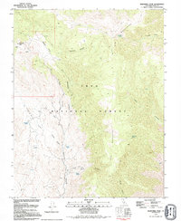
1979 Map of Mazourka Peak
USGS Topo · Published 1994About this map
Mazourka Peak towers over this rugged sector of the Inyo Mountains, a landscape defined by sharp elevation shifts and essential water sources. Surveyed in the late 1970s, the terrain is marked by numerous Mine and Mines symbols alongside scattered Prospects, illustrating the historical importance of mineral exploration in these high canyons. The presence of a Radio Facility near the peak suggests the peak's modern utility for communications, while the broader geography remains largely undeveloped.
Find a feature on this map
29 named features on this map. Tap any name to fly to it.
Don’t see what you’re looking for? This feature index may not catch every label — zoom into the map to look around manually.
Map Details
Editions of this 1979 Mazourka Peak Map
This is the sole edition of this map. No revisions or reprints were ever made.
Other maps of this area

1907 · Mt. Whitney
USGS Topo · 1:125,000

1908 · Lida
USGS Topo · 1:250,000

1908 · Ballarat
USGS Topo · 1:250,000

1913 · Bishop
USGS Topo · 1:125,000

1913 · Lida
USGS Topo · 1:250,000

1913 · Ballarat
USGS Topo · 1:250,000

1919 · Mt. Whitney
USGS Topo · 1:125,000

1937 · Mt. Whitney
USGS Topo · 1:125,000

1947 · Mariposa
USGS Topo · 1:250,000

1948 · Death Valley
USGS Topo · 1:250,000