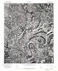
1975 Map of Mc Almont
USGS Topo · Published 1976About this map
North Little Rock and the burgeoning industrial and residential corridors of Pulaski County are revealed in striking detail through this 1975 orthophotomosaic. Unlike a traditional line-and-symbol map, this aerial perspective captures the actual physical footprint of the landscape just as the suburban expansion toward Jacksonville was accelerating. The imagery highlights the massive alluvial bends and oxbow patterns of the river valley, providing a stark contrast between the dense street grids of the city and the complex, scoured agricultural lands to the east. By documenting the exact position of structures and infrastructure at Mc Almont, the map provides a clear record of land use before subsequent decades of development altered the outskirts of the state capital.
Find a feature on this map
3 named features on this map. Tap any name to fly to it.
Don’t see what you’re looking for? This feature index may not catch every label — zoom into the map to look around manually.
Map Details
Editions of this 1975 Mc Almont Map
This is the sole edition of this map. No revisions or reprints were ever made.
Other maps of this area

1891 · Little Rock
USGS Topo · 1:125,000

1893 · Little Rock
USGS Topo · 1:125,000

1935 · Mc Almont
USGS Topo · 1:24,000

1935 · Little Rock
USGS Topo · 1:24,000

1935 · Sweet Home
USGS Topo · 1:24,000

1935 · North Little Rock
USGS Topo · 1:24,000

1935 · Alexander
USGS Topo · 1:48,000

1941 · Alexander
USGS Topo · 1:62,500

1941 · Olmstead
USGS Topo · 1:31,680

1941 · Cabot
USGS Topo · 1:31,680
Featured Places
- North Little Rock, AR
- Jacksonville, AR
- Sherwood, AR
- Lakewood, North Little Rock
- Millers Crossing, Sherwood