
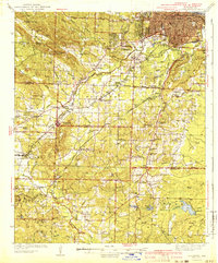
1941 Map of Alexander
USGS Topo · Published 1941About this map
Alexander and the surrounding Arkansas landscape are defined by a complex network of waterways and early 20th-century transportation routes. The Missouri Pacific and Chicago Rock Island and Pacific railroads intersect near settlements like Mabelvale and Brittain, facilitating the movement of materials from the Gravel Pit and industrial areas such as Bauxite. This map reveals a community-focused geography with numerous schools and churches, including the Dawson Sch and Mt Zion Sch, alongside landmark institutions like the Industrial Home and Pineview Memorial Park.
Find a feature on this map
93 named features on this map. Tap any name to fly to it.
Don’t see what you’re looking for? This feature index may not catch every label — zoom into the map to look around manually.
Map Details
Editions of this 1941 Alexander Map
2 editions found
Other maps of this area

1890 · Benton
USGS Topo · 1:125,000

1891 · Little Rock
USGS Topo · 1:125,000

1893 · Little Rock
USGS Topo · 1:125,000

1894 · Benton
USGS Topo · 1:125,000

1932 · Pastoria
USGS Topo · 1:62,500

1935 · Mc Almont
USGS Topo · 1:24,000

1935 · Little Rock
USGS Topo · 1:24,000

1935 · Sweet Home
USGS Topo · 1:24,000

1935 · North Little Rock
USGS Topo · 1:24,000

1935 · Alexander
USGS Topo · 1:48,000