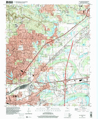
1994 Map of Mc Almont
USGS Topo · Published 2000About this map
North Little Rock and its expanding northern suburbs of Sherwood and Jacksonville are captured in the mid-1990s as major transportation corridors began to define the landscape. The map illustrates the convergence of the St Louis Southwestern RR and Missouri Pacific RR near industrial sites like Protho Junction and the community of McAlmont. These rail lines contrast with the older agrarian patterns along Ink Bayou and the managed landscapes of the Baucum State Nursery. Local heritage is preserved in small burial grounds such as Meacham Cem and Brueny Cem, which sit amidst burgeoning residential developments and institutions like Sylvan Hills High Sch. The western edge is bordered by the sprawling Camp Joseph T Robinson, reflecting the area's dual role as a military hub and a growing metropolitan residential center.
Find a feature on this map
84 named features on this map. Tap any name to fly to it.
Don’t see what you’re looking for? This feature index may not catch every label — zoom into the map to look around manually.
Map Details
Editions of this 1994 Mc Almont Map
This is the sole edition of this map. No revisions or reprints were ever made.
Other maps of this area

1891 · Little Rock
USGS Topo · 1:125,000

1893 · Little Rock
USGS Topo · 1:125,000

1935 · Mc Almont
USGS Topo · 1:24,000

1935 · Little Rock
USGS Topo · 1:24,000

1935 · Sweet Home
USGS Topo · 1:24,000

1935 · North Little Rock
USGS Topo · 1:24,000

1935 · Alexander
USGS Topo · 1:48,000

1941 · Alexander
USGS Topo · 1:62,500

1941 · Olmstead
USGS Topo · 1:31,680

1941 · Cabot
USGS Topo · 1:31,680
Featured Places
- North Little Rock, AR
- Jacksonville, AR
- Sherwood, AR
- Lakewood, North Little Rock
- Millers Crossing, Sherwood