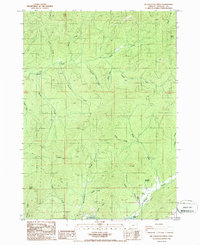
1986 Map of Mc Cullough Creek
USGS Topo · Published 1986About this map
McCullough Creek and its many tributaries, including Lunsbury Creek and Spring Creek, carve through the complex topography of Douglas County in this mid-1980s survey. The landscape is defined by its drainages and prominent elevations like Silver Butte and Panther Butte. This area shows a pattern of resource extraction and water management, evidenced by numerous Quarry sites and a Borrow Pit scattered among the ridges. Water sources are specifically identified, such as Bernstein Spring, Flory Spring, and the contained Hayward Pond, which likely served localized needs in this timbered terrain. The presence of several Prospect labels and a network of 4WD trails suggests an era of active mineral exploration and forest management. Distinctive landmarks like Fir Point and the location named Grayback provide essential reference points for genealogists and local historians tracing the development of rural infrastructure in the Pacific Northwest.
Find a feature on this map
32 named features on this map. Tap any name to fly to it.
Don’t see what you’re looking for? This feature index may not catch every label — zoom into the map to look around manually.
Map Details
Editions of this 1986 Mc Cullough Creek Map
This is the sole edition of this map. No revisions or reprints were ever made.
Other maps of this area

1904 · Riddle
USGS Topo · 1:125,000

1946 · Galice
USGS Topo · 1:62,500

1946 · Dutchman Butte
USGS Topo · 1:62,500

1948 · Galice
USGS Topo · 1:62,500

1948 · Dutchman Butte
USGS Topo · 1:62,500

1954 · Glendale
USGS Topo · 1:62,500

1954 · Canyonville
USGS Topo · 1:62,500

1955 · Medford
USGS Topo · 1:250,000

1957 · Medford
USGS Topo · 1:250,000

1958 · Medford
USGS Topo · 1:250,000