1935 Map of Mc Donald
USGS Topo · Published 1935About this map
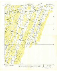
The Southern Railway corridor through Black Fox Valley and Blue Spring Valley anchors this 1935 survey, showing a landscape defined by parallel ridges and early infrastructure. The Tennessee Electric Power Company transmission line and the Lee Highway traverse the northern terrain near McDonald, while industrial signatures like the Grumgoof Mill and its associated flume reveal how the local water systems were harnessed.
Find a feature on this map
45 named features on this map. Tap any name to fly to it.
Don’t see what you’re looking for? This feature index may not catch every label — zoom into the map to look around manually.
Map Details
Editions of this 1935 Mc Donald Map
This is the sole edition of this map. No revisions or reprints were ever made.
Other maps of this area

1886 · Dalton
USGS Topo · 1:125,000

1886 · Cleveland
USGS Topo · 1:125,000

1886 · Ringgold
USGS Topo · 1:125,000

1888 · Chattanooga
USGS Topo · 1:125,000

1892 · Ringgold
USGS Topo · 1:125,000

1892 · Cleveland
USGS Topo · 1:125,000

1892 · Dalton
USGS Topo · 1:125,000

1893 · Chattanooga
USGS Topo · 1:125,000

1895 · Cleveland
USGS Topo · 1:125,000

1897 · Dalton
USGS Topo · 1:125,000