1941 Map of Mc Donald
USGS Topo · Published 1941About this map
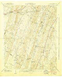
Southern Railway tracks parallel the Lee Highway through the northwest corner of this 1941 Bradley County landscape, serving the community of McDonald. The topography is defined by a series of prominent northeast-trending ridges, including Lebanon Ridge and Black Fox Ridge, which divide narrow fertile valleys like Blue Springs Valley and Maroon Valley. These corridors contain the area's social fabric, with rural institutions like Antioch Church, Lebanon School, and Mt Carmel Church situated along the drainage of Candies Creek and Black Fox Creek.
Find a feature on this map
72 named features on this map. Tap any name to fly to it.
Don’t see what you’re looking for? This feature index may not catch every label — zoom into the map to look around manually.
Map Details
Editions of this 1941 Mc Donald Map
This is the sole edition of this map. No revisions or reprints were ever made.
Other maps of this area

1886 · Dalton
USGS Topo · 1:125,000

1886 · Cleveland
USGS Topo · 1:125,000

1886 · Ringgold
USGS Topo · 1:125,000

1888 · Chattanooga
USGS Topo · 1:125,000

1892 · Ringgold
USGS Topo · 1:125,000

1892 · Cleveland
USGS Topo · 1:125,000

1892 · Dalton
USGS Topo · 1:125,000

1893 · Chattanooga
USGS Topo · 1:125,000

1895 · Cleveland
USGS Topo · 1:125,000

1897 · Dalton
USGS Topo · 1:125,000