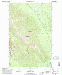
1994 Map of Mc Gee Meadow
USGS Topo · Published 1997About this map
Glacier National Park and the Flathead National Forest dominate this mid-1990s survey, illustrating the complex intersection of federal land management in Montana. The North Fork Flathead River serves as a primary western boundary, where a fishing access point and the Quarter Circle Bridge provide critical connection points to the waterway. Moving east into the interior, the high-altitude topography is defined by the Apgar Mountains, anchored by the Apgar Lookout and Hogback Hill.
Find a feature on this map
24 named features on this map. Tap any name to fly to it.
Don’t see what you’re looking for? This feature index may not catch every label — zoom into the map to look around manually.
Map Details
Editions of this 1994 Mc Gee Meadow Map
This is the sole edition of this map. No revisions or reprints were ever made.
Other maps of this area

1904 · Chief Mountain
USGS Topo · 1:125,000

1906 · Kintla Lakes
USGS Topo · 1:125,000

1914 · Nyack
USGS Topo · 1:125,000

1938 · Chief Mountain
USGS Topo · 1:125,000

1938 · Kintla Lakes
USGS Topo · 1:125,000

1943 · Kalispell
USGS Topo · 1:125,000

1957 · Kalispell
USGS Topo · 1:250,000

1960 · Kalispell
USGS Topo · 1:250,000

1960 · Cut Bank
USGS Topo · 1:250,000

1961 · Kalispell
USGS Topo · 1:250,000