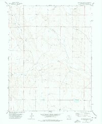
1978 Map of Mc Kenzie Draw
USGS Topo · Published 1978About this map
Mc Kenzie Draw defines the drainage of this high plains landscape in Lincoln County, where the semi-arid terrain is marked by a complex network of ephemeral water sources. The map records a series of vital water points for the local cattle industry, including Lofdahl Springs, the isolated Evilsizer Lake, and numerous wells scattered across the township lines. The small settlement of Wezel sits near the confluence where the landscape transitions between North Rush Creek and South Rush Creek. This 1970s survey captures the region's ranching infrastructure, meticulously documenting fence lines and local livestock improvements such as a water Tank and windmills, identified by the label WM, which supported life in this corner of eastern Colorado.
Find a feature on this map
17 named features on this map. Tap any name to fly to it.
Don’t see what you’re looking for? This feature index may not catch every label — zoom into the map to look around manually.
Map Details
Editions of this 1978 Mc Kenzie Draw Map
This is the sole edition of this map. No revisions or reprints were ever made.
Other maps of this area

1889 · Sanborn
USGS Topo · 1:125,000

1891 · Sanborn
USGS Topo · 1:125,000

1891 · Arroyo
USGS Topo · 1:125,000

1893 · Arroyo
USGS Topo · 1:125,000

1893 · Sanborn
USGS Topo · 1:125,000

1954 · Lamar
USGS Topo · 1:250,000

1958 · Lamar
USGS Topo · 1:250,000

1975 · Stanley Gulch
USGS Topo · 1:24,000
1978 · Beckman Lake
USGS Topo · 1:24,000
1978 · Kinney Lake
USGS Topo · 1:24,000