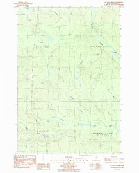
1986 Map of Mc Nally Ridge
USGS Topo · Published 1987About this map
McNally Ridge and Maple Ridge dominate the landscape of this northern Maine interior, which was documented during the mid-1980s. The region is defined by its complex network of waterways, centered on the St Croix Stream and various tributaries such as Boody Brook and Hastings Brook. The area is largely organized by traditional township designations like T 8 R 5 W E L S and Webbertown (T 7 R 4 W E L S), reflecting the systematic survey of timberlands. Human presence is sparse, marked primarily by utilitarian features like a Gravel Pit in the south and a Roadside Park in the northwest. The presence of Roll Dam Brook hints at the legacy of the local logging industry, where waterways were managed to transport timber through the wilderness. This map provides a detailed view of the terrain and water systems that shaped the industrial and recreational character of Aroostook County.
Find a feature on this map
19 named features on this map. Tap any name to fly to it.
Don’t see what you’re looking for? This feature index may not catch every label — zoom into the map to look around manually.
Map Details
Editions of this 1986 Mc Nally Ridge Map
This is the sole edition of this map. No revisions or reprints were ever made.
Other maps of this area

1935 · Howe Brook
USGS Topo · 1:48,000

1937 · Smyrna Mills
USGS Topo · 1:62,500

1939 · Howe Brook
USGS Topo · 1:62,500

1940 · Island Falls
USGS Topo · 1:62,500

1940 · Oxbow
USGS Topo · 1:62,500

1942 · Island Falls
USGS Topo · 1:62,500

1942 · Oxbow
USGS Topo · 1:62,500

1954 · Howe Brook
USGS Topo · 1:62,500

1954 · Presque Isle
USGS Topo · 1:250,000

1955 · Smyrna Mills
USGS Topo · 1:62,500
Featured Places
- T8 R5 WELS, ME
- Webbertown Township, ME
- T7 R5 WELS, ME
- Pride, Saint Croix Township
- Saint Croix Township, ME