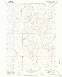
1968 Map of Mc Pherson Draw
USGS Topo · Published 1972About this map
Mc Pherson Draw carves through the central high plains of Natrona County, revealing a landscape defined by resource extraction and sparse ranching infrastructure during the late 1960s. The terrain is marked by an extensive network of pipelines and pipelines that intersect the undulating topography, connecting scattered energy sites such as Oil Wells and numerous Drill Holes. This industrial activity shares the land with remote water sources like Seventeenmile Well, which provided essential support for livestock in an otherwise arid environment.
Find a feature on this map
13 named features on this map. Tap any name to fly to it.
Don’t see what you’re looking for? This feature index may not catch every label — zoom into the map to look around manually.
Map Details
Editions of this 1968 Mc Pherson Draw Map
2 editions found
Other maps of this area

1949 · Pratts Soda Lakes
USGS Topo · 1:24,000

1950 · Pratts Soda Lakes
USGS Topo · 1:24,000

1951 · The Reefs
USGS Topo · 1:24,000

1952 · Bishop
USGS Topo · 1:24,000

1955 · Arminto
USGS Topo · 1:250,000

1955 · Casper
USGS Topo · 1:250,000

1958 · Casper
USGS Topo · 1:250,000

1958 · Arminto
USGS Topo · 1:250,000

1959 · Ormsby Draw
USGS Topo · 1:62,500
1960 · Bishop
USGS Topo · 1:24,000