
1952 Map of Bishop
USGS Topo · Published 1952About this map
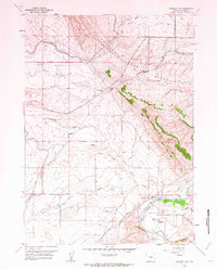
Casper Air Force Base dominates the southern portion of this mid-century survey, displaying a dense network of runways, firing bunkers, and a Control Tower. This military installation is flanked by the Chicago and Northwestern railroad, which tracks alongside Casper Creek through the small settlements of Cadoma and Bishop. The map reveals a landscape undergoing significant transition, where agricultural and industrial infrastructure is already being marked as obsolete.
Find a feature on this map
18 named features on this map. Tap any name to fly to it.
Don’t see what you’re looking for? This feature index may not catch every label — zoom into the map to look around manually.
Map Details
Editions of this 1952 Bishop Map
This is the sole edition of this map. No revisions or reprints were ever made.
Other maps of this area

1950 · Emigrant Gap
USGS Topo · 1:24,000

1950 · Goose Egg
USGS Topo · 1:24,000

1950 · Emigrant Gap NE
USGS Topo · 1:24,000

1951 · The Reefs
USGS Topo · 1:24,000

1951 · Casper
USGS Topo · 1:24,000

1955 · Arminto
USGS Topo · 1:250,000

1955 · Casper
USGS Topo · 1:250,000

1958 · Casper
USGS Topo · 1:250,000

1958 · Arminto
USGS Topo · 1:250,000
1960 · Emigrant Gap
USGS Topo · 1:24,000