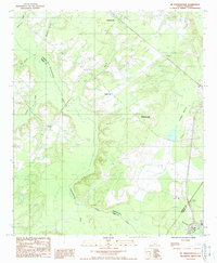
1988 Map of Mc Phersonville
USGS Topo · Published 1988About this map
Mcphersonville and the winding course of the Coosawhatchie River anchor this Lowcountry landscape in the late 1980s. The map illustrates a region defined by its water systems and scattered rural settlements, where the river serves as a natural boundary between Hampton and Jasper counties. Tributaries such as Mcpherson Creek, Cypress Creek, and Tulifiny River thread through the terrain, supporting the agricultural and timber-driven economy of the era. Small communities like Early Branch, Barkerville, and the evocatively named Possum Corner are linked by a network of rural roads, while a Lookout Tower near the county line suggests the importance of forest management. The presence of Davidson and Kress along the eastern edge, combined with features like Buckfield and Backwater, reflects a geography deeply tied to the coastal plains' unique hydrological patterns and local lineage.
Find a feature on this map
21 named features on this map. Tap any name to fly to it.
Don’t see what you’re looking for? This feature index may not catch every label — zoom into the map to look around manually.
Map Details
Editions of this 1988 Mc Phersonville Map
This is the sole edition of this map. No revisions or reprints were ever made.
Other maps of this area

1918 · Varnville
USGS Topo · 1:62,500

1918 · Yemassee
USGS Topo · 1:62,500

1919 · Pineland
USGS Topo · 1:62,500

1919 · Cummings
USGS Topo · 1:62,500

1943 · Pineland
USGS Topo · 1:62,500

1943 · Yemassee
USGS Topo · 1:62,500

1943 · Cummings
USGS Topo · 1:62,500

1944 · Varnville
USGS Topo · 1:62,500

1947 · Savannah
USGS Topo · 1:250,000

1948 · Savannah
USGS Topo · 1:250,000