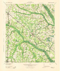
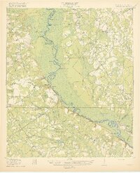
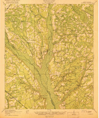
1944 Map of Varnville
USGS Topo · Published 1944About this map
Hampton and Varnville serve as central hubs in this mid-1940s landscape, where a dense network of country schools and rural churches defines the community structure. The terrain is deeply influenced by the winding paths of the Coosawhatchie River and Pocotaligo River, which create broad swampy basins like Whippy Swamp and Cow Swamp. The map reveals a highly connected era of rail transport, showing the Charleston and Western Carolina and the Seaboard Railway intersecting at Fairfax, while the Hampton and Branchville line links the smaller timber and agricultural settlements. Genealogists will find a wealth of named landmarks, including Jackson Branch Sch, Bethlehem Ch, and Shumans Store, reflecting a time when local life was anchored by small, neighborhood-specific institutions and family-named crossroads like Cleland Crossroads.
Find a feature on this map
69 named features on this map. Tap any name to fly to it.
Don’t see what you’re looking for? This feature index may not catch every label — zoom into the map to look around manually.
Map Details
Editions of this 1944 Varnville Map
This is the sole edition of this map. No revisions or reprints were ever made.
Other maps of this area

1918 · Varnville
USGS Topo · 1:62,500

1918 · Yemassee
USGS Topo · 1:62,500

1919 · Pineland
USGS Topo · 1:62,500

1919 · Olar
USGS Topo · 1:62,500
1919 · Shirley
USGS Topo · 1:62,500

1919 · Allendale
USGS Topo · 1:62,500
1919 · Cummings
USGS Topo · 1:62,500

1919 · Lodge
USGS Topo · 1:62,500

1920 · Lodge
USGS Topo · 1:48,000

1920 · Peeples
USGS Topo · 1:62,500