
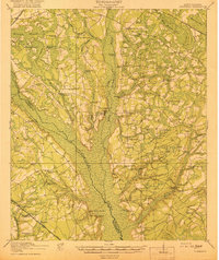
1919 Map of Lodge
USGS Topo · Published 1974About this map
The Edisto River and Little Salkehatchie River define the low-lying terrain of this 1919 landscape, where extensive swamp systems like Schofield Swamp and Little Swamp dictated the placement of early South Carolina settlements. The town of Branchville sits at a critical junction in the north, while the Atlantic Coast Line and the specialized Lumber RR track the economic dependence on timber and regional transit. This survey reveals a dense network of local institutions essential to rural life, including schools like McIlhenny School and Hopewell School, alongside numerous country churches such as Hunters Chapel and Carter Ford Church. The placement of Sandy Island Bridge and Potts Bridge highlights the historical river crossings that connected these disparate farming communities before the modern highway system restructured the region.
Find a feature on this map
65 named features on this map. Tap any name to fly to it.
Don’t see what you’re looking for? This feature index may not catch every label — zoom into the map to look around manually.
Map Details
Editions of this 1919 Lodge Map
This is the sole edition of this map. No revisions or reprints were ever made.
Other maps of this area

1918 · Walterboro
USGS Topo · 1:62,500

1918 · Varnville
USGS Topo · 1:62,500

1919 · Olar
USGS Topo · 1:62,500

1919 · Bamberg
USGS Topo · 1:48,000
1919 · Cummings
USGS Topo · 1:62,500

1920 · Bowman
USGS Topo · 1:48,000

1920 · Lodge
USGS Topo · 1:48,000

1920 · Bamberg
USGS Topo · 1:62,500
1920 · Orangeburg
USGS Topo · 1:48,000

1920 · St. George
USGS Topo · 1:48,000