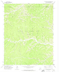
1971 Map of Mc Williams Canyon
USGS Topo · Published 1974About this map
The Beaubien and Miranda Grant (Maxwell) territory dominates this northern New Mexico landscape, where the Canadian River cuts through a dense network of named drainages along the Colorado border. This early 1970s survey documents a region defined by its deep canyons and early industry, featuring locations like Shingle Mill Canyon and Sawmill Canyon that suggest the area's timber history. Human activity is concentrated along specific corridors, notably the York Canyon Road and a scattering of remote infrastructure including a Mine and several recorded Drill Hole locations. The terrain is heavily dissected, with family-named features such as Mc Cuen Canyon, Bruggerman Canyon, and Doyle Canyon providing valuable identifiers for local historians. Water sources are precious and specifically noted, including Joe Baker Spring and other unnamed springs that historically supported the ranching and resource extraction across the Colfax County line.
Find a feature on this map
44 named features on this map. Tap any name to fly to it.
Don’t see what you’re looking for? This feature index may not catch every label — zoom into the map to look around manually.
Map Details
Editions of this 1971 Mc Williams Canyon Map
This is the sole edition of this map. No revisions or reprints were ever made.
Other maps of this area

1891 · Spanish Peaks
USGS Topo · 1:125,000

1893 · Spanish Peaks
USGS Topo · 1:125,000

1895 · Spanish Peaks
USGS Topo · 1:125,000

1897 · Spanish Peaks
USGS Topo · 1:125,000

1900 · Spanish Peaks
USGS Topo · 1:125,000

1915 · Brilliant
USGS Topo · 1:62,500

1951 · Valdez
USGS Topo · 1:24,000
1951 · Starkville
USGS Topo · 1:24,000

1954 · Raton
USGS Topo · 1:250,000

1954 · Trinidad
USGS Topo · 1:250,000