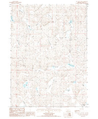
1986 Map of McCarty Lake
USGS Topo · Published 1986About this map
McCarty Lake and the surrounding Garden County landscape appear here as a complex network of ephemeral waters and named valleys in the mid-1980s. The terrain is defined by a distinct orientation of landforms, with drainages like Hog Valley and Tree Claim Valley cutting through the sandy elevations. The distribution of water bodies, including the centrally located Clark Lake and the southern H Lotspeich Lake, suggests a high water table characteristic of this Nebraska Sandhills region, where many lakes rely on groundwater seepage.
Find a feature on this map
23 named features on this map. Tap any name to fly to it.
Don’t see what you’re looking for? This feature index may not catch every label — zoom into the map to look around manually.
Map Details
Editions of this 1986 McCarty Lake Map
This is the sole edition of this map. No revisions or reprints were ever made.
Other maps of this area

1948 · Bingham
USGS Topo · 1:62,500

1948 · Lakeside
USGS Topo · 1:62,500

1949 · Mumper
USGS Topo · 1:62,500

1950 · Longfellow Lake
USGS Topo · 1:62,500

1950 · Lakeside
USGS Topo · 1:62,500

1950 · Bingham
USGS Topo · 1:62,500

1954 · Scottsbluff
USGS Topo · 1:250,000

1955 · Alliance
USGS Topo · 1:250,000

1957 · Alliance
USGS Topo · 1:250,000

1958 · Alliance
USGS Topo · 1:250,000