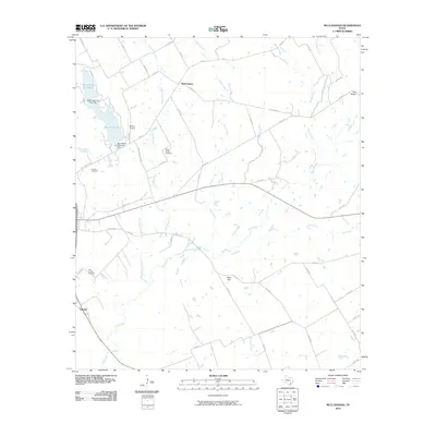
2010 Map of McClanahan
USGS Topo · Published 2010About this map
McClanahan and Sunrise anchor this agricultural landscape in Falls County, where a network of rural roads connects scattered homesteads and burial grounds. The territory is defined by the winding paths of Big Creek, Keechi Creek, and Little Sandy Creek, which feed into the local water system including Marlin Old City Lake and New City Lake. Topography is relatively gentle, though Bald Hill rises as a distinct landmark in the southern portion of the quadrangle. For those researching local history, the map identifies several key sites such as the Taylor Chapel Cemetery, Hillcrest Cemetery, and the Falls County Cemetery. Evidence of transportation and infrastructure appears in the form of the Marlin Airport and the Bell Bridge, while farm-to-market roads like FM 147 and FM 2958 demonstrate the connectivity between these small Texas communities and their surrounding fields.
Find a feature on this map
56 named features on this map. Tap any name to fly to it.
Don’t see what you’re looking for? This feature index may not catch every label — zoom into the map to look around manually.
Map Details
Editions of this 2010 McClanahan Map
This is the sole edition of this map. No revisions or reprints were ever made.
Other maps of this area

1954 · Waco
USGS Topo · 1:250,000

1955 · Waco
USGS Topo · 1:250,000

1957 · Otto
USGS Topo · 1:24,000

1957 · McClanahan
USGS Topo · 1:24,000

1957 · Riesel
USGS Topo · 1:24,000

1957 · Marlin
USGS Topo · 1:24,000

1962 · Reagan
USGS Topo · 1:24,000

1962 · Cedar Springs
USGS Topo · 1:24,000

1962 · Bremond
USGS Topo · 1:24,000

1965 · Kosse West
USGS Topo · 1:24,000