1955 Map of Waco
USGS Topo · Published 1955About this map
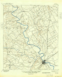
The Brazos River corridor dominates this mid-century landscape, anchored by the central hub of Waco and its expanding neighbors Bellmead and Lacy-Lakeview. The map captures a moment of significant military and infrastructure development, showing the sprawling Fort Hood Military Reservation in the southwest alongside numerous aviation facilities like Connally AFB and Gray Air Force Base. Water management projects of the era are clearly visible, including the massive Whitney Reservoir and the Belton Reservoir on the Leon River. The region's transport economy is defined by the intersection of Interstate 35 and a dense network of railroads like the St Louis Southwestern and Missouri Pacific. Local history details emerge in the form of institutions like the State Reform School and rural landmarks such as Terry Chapel, reflecting the area's mix of institutional growth and established ranching country.
Find a feature on this map
70 named features on this map. Tap any name to fly to it.
Don’t see what you’re looking for? This feature index may not catch every label — zoom into the map to look around manually.
Map Details
Editions of this 1955 Waco Map
This is the sole edition of this map. No revisions or reprints were ever made.
Historical Maps of Killeen Through Time
5 maps found