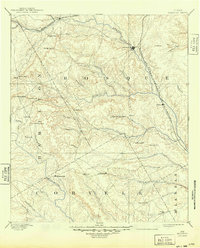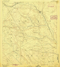
1888 Map of Meridian
USGS Topo · Published 1888About this map
Bosque River valley dominates this late nineteenth-century view, anchoring a landscape where river drainage and burgeoning rail lines dictated early Texas settlement. The town of Meridian sits at the crossing of the Gulf Colorado and Santa Fe Railroad, while to the northwest, Iredell serves as a key point on the Texas Central Railroad. This survey, conducted under the direction of J.W. Powell, illustrates a transition from the river-dependent outposts like Jonesborough on the Leon River to the upland gap settlements such as Cranfills Gap. The terrain is marked by family-named landmarks and distinctive elevations like Sugar Loaf Mountain and Johnson Peak, providing a clear look at the rural crossroads of Coryell and Bosque counties before the modern highway network altered these traditional trade routes.
Find a feature on this map
55 named features on this map. Tap any name to fly to it.
Don’t see what you’re looking for? This feature index may not catch every label — zoom into the map to look around manually.
Map Details
Editions of this 1888 Meridian Map
This is the sole edition of this map. No revisions or reprints were ever made.
Historical Maps of Clifton Through Time
8 maps found