1891 Map of Cleburne
USGS Topo · Published 1891About this map
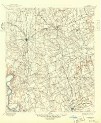
Cleburne and Hillsboro anchor this late-nineteenth-century landscape, appearing as primary rail hubs during a period of rapid North Texas expansion. The intricate network of the Gulf Colorado and Santa Fe Railway and the Missouri Kansas and Texas Railway reveals how rail competition drove the development of towns like Alvarado and Grand View. In the southwest corner, the Brazos River carves a deep path near the early settlement of Kimball, while the Nolands River system drains the central prairie. Small communities such as Marystown, Egan, and Covington are meticulously noted, many having formed around rural post offices and stage stops. The terrain is defined by prominent landmarks like Caddo Peak and Brushy Knob, which served as critical navigation points for travelers long before the arrival of the St. Louis Arkansas and Texas Ry. along the eastern edge of Hill County.
Find a feature on this map
69 named features on this map. Tap any name to fly to it.
Don’t see what you’re looking for? This feature index may not catch every label — zoom into the map to look around manually.
Map Details
Editions of this 1891 Cleburne Map
This is the sole edition of this map. No revisions or reprints were ever made.
Historical Maps of Grand Prairie Through Time
3 maps found